My previous series of posts detailed a walk which had been on the backburner for a number of years. That’s nothing though. This one well and truly put the burn into the back, as it was years ago when I first considered an attempt. Way back when Moses won the 400 metre hurdles. So what’s it all about?
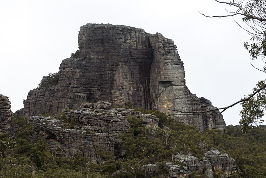
The Fortress circuit, Grampians National Park is a 34 km walk that’s normally undertaken over three days. On the first day, it begins at Harrop Track and takes on the Fortress within the Victoria Range. The second day consists of a wander up to Mt Thackeray, before looping back to the start on the third day.
Okay, that’s the formalities over with. It’s always quite painful writing something like the previous paragraph. What’s this joint turning into? A travelogue? A guide book? I’m scared to think it’s turning normal. Maybe I need to ramp things up, otherwise this place will be awash with beige and vanilla in no time.
Anyway, as is the way with multi-day walks in here, this opening post is essentially guff only. As I write up each particular day, I’ll add them to the end of this post. The most important part of the last sentence is, ‘as I write up’. At best, you might get one a week. At the worst, you could be waiting a decade, as I’m a very busy man. Do you realise how many movies I’m trying to catch up on?
Okay, so I eventually did the Fortress circuit after many years of it sitting in my ‘to do’ list. The thing is though. Why did it take so long? Ah, there was a litany of reasons, which cropped up over time. Once, I was all ready to drive up and get it done. With the car loaded the night before, all I had to do was wander out in the early morning and power my way to the start. Except, as I stumbled out into the driveway and rubbed my eyes in the dawn light, I was confronted with a flat tyre on the car. So that was the end of that. As any punter with a similar car knows. You can’t go driving 250 km with a space saver spare wheel that’s rated to about 7 kph.
Mm… what else? Oh, once I thought I’d do the Fortress leg as a day walk only. It’s detailed in GT’s book, Daywalks Around Victoria, so it all seemed quite straightforward. Just use a day pack and all that lightweight business. At the time though, I was in Halls Gap and as the Fortress is a bit of a drive from there, I asked the local information centre for some directions. They gave me a magnificent route, which I detailed in full. Until I drove it and after some distance suddenly was confronted with a barrier with a huge ‘road closed’ sign on it. Huh? As you can see, there were so many hiccups in doing this walk, I started to think it was a government conspiracy.
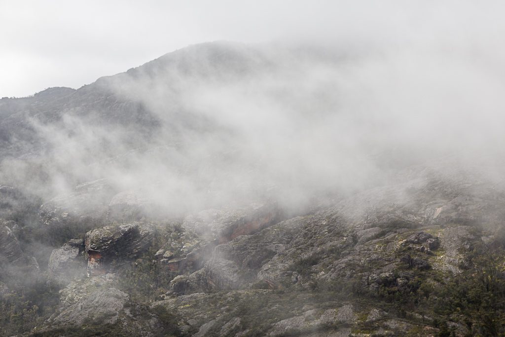
In the end though, the stars aligned and in winter, I finally made it to the start. Actually, it was right at the end of August, so although it was technically winter, it didn’t really feel like it. There was a balmy spring feeling and the flowers were well and truly out. Except for some classic oddball weather on the first day, which combined visibility reduced low cloud to bright sunshine, I had more or less calm conditions.
The default setting for most of my walks is I never run into anyone and this was no different. I didn’t see another person in the three days. Also, it was classic Grampians. At times sublime, but with a twist of bonkers. One moment you’re in the middle of what feels like nowhere and then 10 minutes later, they’ve sent you down a road where you’re left ticking over the distance. Cursing the powers to be who have never made the most of what the Grampians can offer. Generally, formal walks are day only and the multi-day have sections that consist of the frightening phrase, ‘4WD road walking’. Huh? If anything can knock out a walking boner, it’s an extended stroll on a road.
On paper, the Grampians Peak Trail should end this and its 144 km sounds suitably epic. What’s interesting is they still aim to have it finished in 2019. As it stands, there seems to be a ton of work in not a lot of time, so I’m intrigued if it opens by the dates intended. Hang on, I just looked at the intended map for the GPT and it doesn’t go near the Fortress or the Victoria Range. What is this insanity? Am I seeing things?
Anyway, there’s not a lot to this post, as anything else would just be spoilers for what is to come. One admission I’d make is in regard to maps. I well and truly catered for this one. I had so much paperwork, I began to think I’d lost the plot. My main guide were the notes found in John Chapman’s ‘Bushwalking in Australia’ and even though they’re up to 30 years old, there were no recent shocks. Beforehand, I was a little concerned with the times suggested over distance. In the universe there are two times. Human and Chapman. Both can vary greatly. I’m always intrigued by his photos as well. Some are probably recent, but then again, they could have been taken in 1975. They’re always entertaining.
One other thing. I’m cutting back on anecdotes. I figure if I’ve got a book in me, then all the good stories can’t be wasted by giving them away in the blog for free. Sure, there’ll still be observations. Such as, why do fish and chip shops offer chicken salt with so much enthusiasm and fanfare, you’d think they were throwing in a free lobster? Unfortunately for you, thoughts like that will continue. Not the good stories though. Like the time I had to run after a naked bloke with an air-conditioner up his arse or the evening where I locked my car door as some bloke tried to hop in. Oh, if you’re wondering, the locking wasn’t done in fear of a stranger. I did it as he had a bee hive on his head. As you can see, these should be in a book.
Anyway, that’s it for now. Next up will be day one. Harrop Track to the Fortress Camp. I’ll have it written within a week. Either this century or next.
Day 1. Harrop Track to the Fortress
Day 2. Fortress Camp to Mt Thackeray Camp.

Well after a promising start with a grand title and awesome photo I gather the prolific maps and planning, not to mention teasers (of anecdotes to appear in a later book)left little time for actual hiking. I look forward to the continuing (start) of this epic walk. Reminds me of that old joke how do you keep an idiot in suspense, i’ll tell you later!
Oh yeah, I should have put something different in the heading such as, ‘This is about the Fortress, but it actually isn’t’! What’s worse is I’ve now got to write up the first day, which was the most interesting of the three days. I think I’ll need an editor 🙂
It definitely seems unlikely they’ll get the peaks trail done, especially as they say they are going to work outwards from the completed section which only has one finished camp. The Borough Huts camp is still the old drive-in campground…
I’ll miss the usual anecdotes but look forward to reading them in your book – signed copies for loyal blog followers? A bee-hive on a head and an air-conditioner stuck where??? Can’t wait! 🙂
Yeah, I was thinking the same thing, but anything I read still announces it being 2019. I thought it was already funded, so I’m not sure why it’s progressing at glacial speed? Mind you, if they do finish it, it’ll be interesting how they keep it all up and running. The Grampians has it fair share of fires and floods. I think the Mt Difficult loop was closed for over 3 years after the last lot of fires? Then again, maybe it’s still shut…?! 🙂
Oh, there’s still bound to be plenty of waffle. Just not extended forays of crap that I usually include 🙂 The best thing about those two stories I mentioned is I don’t have to remotely embellish them. It’s all true!